
In June 2023, the California American Water Company (CalAm) applied to the Commission for a lease to construct and use four new subsurface slant wells and for the conversion and use of one existing subsurface slant well for use in CalAm’s Monterey Peninsula Water Supply Project seawater desalination plant. As part of a phased approach, CalAm proposes to construct a 4.8 million gallons per day desalination plant located about 2 miles inland of the proposed slant well field within the jurisdiction of Monterey County. Brine would be discharged from an existing 60-inch ocean outfall pipeline, owned and operated by Monterey One Water. Consideration of any proposed modifications to the outfall or authorization to discharge brine from the outfall are subject to further Commission action and are not part of the proposed CalAm lease.
Environmental Justice Outreach and Community Engagement
In December 2023, staff sent environmental justice outreach letters to 21 organizations in Monterey County and participated in phone calls with individuals representing local citizen groups or other organizations. In December 2024, staff met with the City of Marina and held two outreach sessions to solicit public comments on the overall project, including the portion within the Commission’s jurisdiction. Members of the public representing communities within the Monterey Peninsula attended, as well as other organizations and local agencies.
Tribal Consultation
In December 2023, staff sent tribal consultation letters to multiple tribes traditionally and culturally affiliated with the proposed project area. Several tribes responded, and one tribe requested formal consultation.
Environmental Memorandum
As a Responsible Agency under the California Environmental Quality Act (CEQA), staff prepared an Environmental Memorandum to document that no additional CEQA analysis is required and to inform the Commission’s action to consider a lease for the elements of the Monterey Peninsula Water Supply Project within the Commission’s jurisdiction.
Frequently Asked Questions
What is the Commission's jurisdiction at the proposed lease location?
The Commission manages roughly four million acres of tide and submerged lands and the beds of natural navigable rivers, streams, lakes, bays, estuaries, inlets, and straits, along with other proprietary lands throughout the state. The boundary of the Commission’s jurisdiction at the CalAm site is the ordinary high water mark as generally shown by the mean high tide line. CalAm’s existing test slant well extends approximately 196 feet below the surface onto sovereign land, and is under lease with the Commission. The four proposed slant wells would extend approximately 130 to 160 feet onto sovereign land and would terminate about 200 feet below the ocean floor.
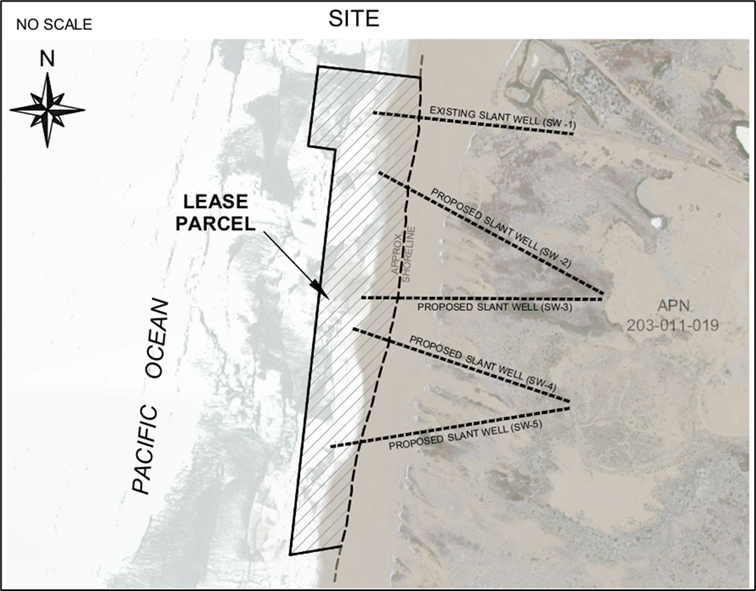
Site map showing the location of the proposed lease area, four proposed slant wells, and the existing test slant well.
What is the scope of the Commission’s approval for CalAm’s proposed project?
CalAm has applied to the Commission for a General Lease for the construction and use of four new subsurface slant wells and the conversion and use of one existing subsurface slant well for use in CalAm’s seawater desalination plant. Other components of the project, including the slant well pads, water transportation pipelines, and the desalination facility, are proposed to be located farther inland above the mean high tide line and are outside the Commission’s jurisdiction.
What right does CalAm have to use the upland and beach area?
CalAm has been using the upland area under a legal right granted by the private upland landowner, RMC Pacific Materials (d/b/a CEMEX). The landowner granted several easements to CalAm, beginning with a temporary, 24-month easement to CalAm in 2014 that was later amended to extend the use period until February 2018. The landowner granted a permanent easement to CalAm in 2018. The slant well easement occupies approximately 30 acres of the approximately 400-acre CEMEX site, and it allows for “accessing, constructing, installing, operating, and maintaining slant wells and related pipelines and utilities for a desalination facility to be constructed by Grantee [CalAm], including such items as wellhead vaults, underground electrical conduit, underground water transmission pipelines, electrical panels, and related appurtenances, as well as signs, markers, and similar notices and warnings as may be necessary to identify the location of any underground pipelines, utilities, or equipment.”
What is the status of achieving public access through the upland property?
The upland property is privately owned by RMC Pacific Materials (d/b/a CEMEX). The Commission’s understanding is that some areas of the beach are under periodic access restrictions during the Snowy Plover nesting season.
In 2017, the California Coastal Commission and the State Lands Commission negotiated a Settlement Agreement that requires CEMEX to eventually transfer the land associated with its former beach sand mining operation to a nonprofit or governmental entity or consortium approved by the State Lands Commission in consultation with the City of Marina. This land transfer has not occurred, but may occur before or after CEMEX completes mine reclamation required by the Surface Mining and Reclamation Act. Before the land is transferred, it must be placed under a deed restriction “to preserve the open space and habitat values of the property” that allows for public access. (see above, “What right does CalAm have to use the upland and beach area?“). Any open space or recreation uses for the site must be consistent with the easement.
Will the Commission determine if CalAm has a legal right to withdraw water for the proposed desalination project?
No. While the Commission is in some situations an owner of water rights associated with the lands it owns, it does not regulate water rights. Surface water rights and groundwater rights determinations are under the purview of the State Water Resources Control Board. For this reason, the Commission will not determine whether CalAm has a legal right to withdraw subsurface water.
In June 2025, the State Water Resources Control Board Administrative Hearing Office issued a Final Report as Referee in City of Marina v. RMC Lonestar (Lonestar), Superior Court of California, County of Monterey, Case No. 20CV001387. The report was issued pursuant to the court’s order of October 7, 2021, seeking the expert opinion of the State Water Resources Control Board. The Superior Court will consider the report as evidence in the ongoing litigation, as provided in section 2019 of the Water Code.
The Commission requires lessees to obtain and comply with all required permits. For this proposed lease, one of those permits is the Coastal Commission’s Coastal Development permit. The permit contains a condition related to the Lonestar case requiring CalAm to obtain a favorable judgment from the court or an order from the SWRCB demonstrating that (1) CalAm has, or can feasibly obtain, water rights (to the extent applicable) for the Project and (2) Cal-Am’s project would not cause harm to any aquifer that is a source of drinking water to the City of Marina or the Marina Coast Water District.
Will the Commission consider water supply and demand estimates in consideration of the lease?
No. The Commission has no jurisdiction or regulatory authority over the review and adoption of water supply and demand estimates. The California Public Utilities Commission (CPUC) Water Division has primary regulatory authority and jurisdiction over privately-owned water utilities, including CalAm. On August 14, 2025, the CPUC issued and adopted Decision 25-08-006, which updated the water supply and demand estimates of the MPWSP. The CPUC later issued a corrective order, Decision 25-10-001. The CPUC decisions adopted a water supply estimate of 11,204 acre-feet per year for the Monterey Peninsula Water Supply Project and a projected 2050 water demand of 13,732 acre-feet per year. Thus, a water supply shortfall of 2,528 acre-feet per year is projected.
What actions has the Coastal Commission taken?
On November 17, 2022, the California Coastal Commission conditionally approved a Coastal Development permit for the Monterey Peninsula Water Supply Project. The Staff Report and Addendum are available on the Coastal Commission’s website. The Coastal Commission’s Final Adopted Findings are available on our website. Many of the permit conditions remain outstanding, and the Permit has not yet been issued. A more detailed status of the permit conditions will be provided in the State Lands Commission staff report when it becomes available.
Next Steps and How to Participate
Staff anticipate bringing CalAm’s lease application before the Commission for consideration at a future meeting. Hybrid participation will be available. The meeting agenda will be posted at least 10 days before the meeting.
While the agendas for upcoming Commission meetings have not been posted, members of the public are welcome to submit comments now. Comments can be submitted at any time to CalAm@slc.ca.gov. Once the agenda is posted, please submit written comments at least 3 business days before the meeting so the Commissioners have sufficient time to review before the meeting. Comments and feedback received, including all comments made during previous outreach efforts, will be summarized for the Commissioners.
To receive notices of Commission meetings, including the location and time, please subscribe to receive email updates. Additional information on public participation and meeting procedures is available on our website.
Links and Resources
- Environmental Impact Report/Environmental Impact Statement (EIR/EIS) for the Monterey Peninsula Water Supply Project
- California Coastal Commission Staff Report, Addendum, and Final Adopted Findings
- State Lands Commission / CEMEX Settlement Agreement Staff Report
(includes copies of the State Lands Commission Settlement Agreement and Coastal Commission Consent Order regarding CEMEX sand mining operation)