
On Thursday, August 13, 2026, the Commission will host two virtual public information-sharing webinars regarding a report it is undertaking related to offshore oil and gas pipeline leases. The Commission will hold two 60-minute sessions, one at 2:00 p.m. and one at 6:00 p.m.
These webinars relate to the Commission’s December 2023 direction (Item 59) for staff to develop an Analysis of Impacts to Public Trust Resources and Values (APTR or Report) for the remaining offshore oil and gas pipeline leases under its jurisdiction. The APTR will assess the risks and impacts of continued offshore pipeline use and will include additional analyses (e.g., related to pipeline integrity, cultural resources, ocean and coastal uses, economic resources, etc.), and it will inform the Commission’s future decisions about these leases.
Frequently Asked Questions
- What is the California State Lands Commission?
- How many pipelines are included in the APTR, and where are they located?
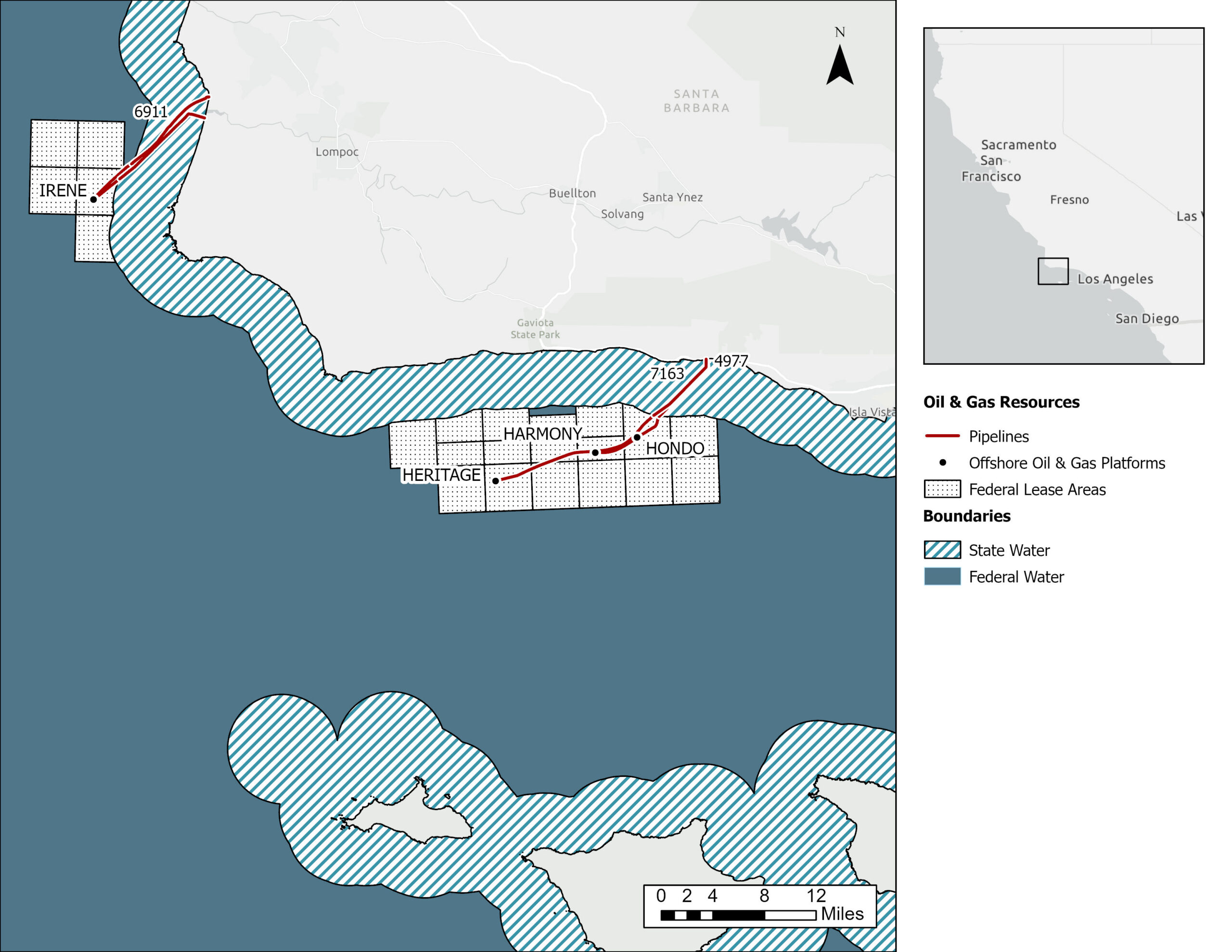
- Which offshore oil and gas pipelines are included in the APTR off of central and northern Santa Barbara County?
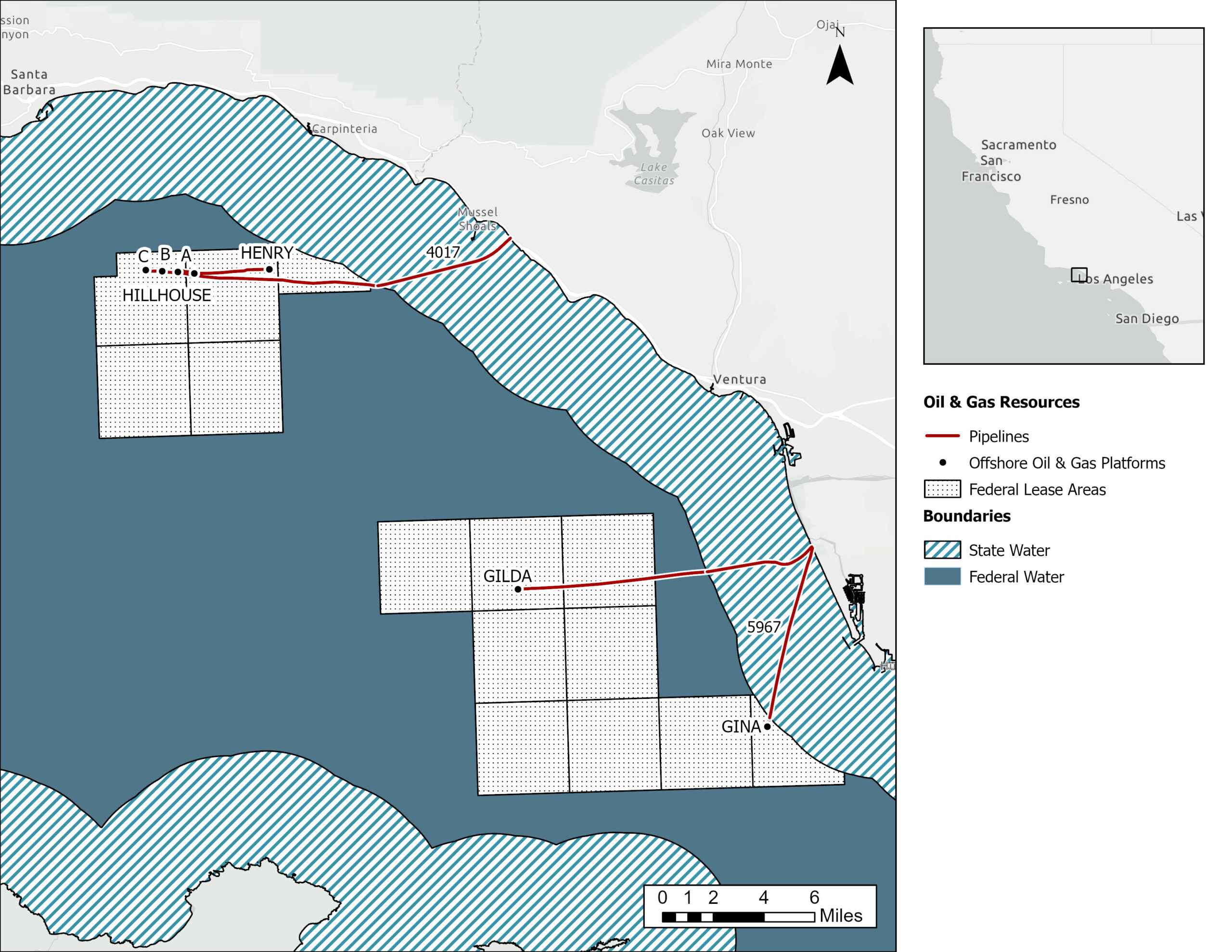
- Which offshore oil and gas pipelines are included in the APTR off of southern Santa Barbara and northern Ventura Counties?
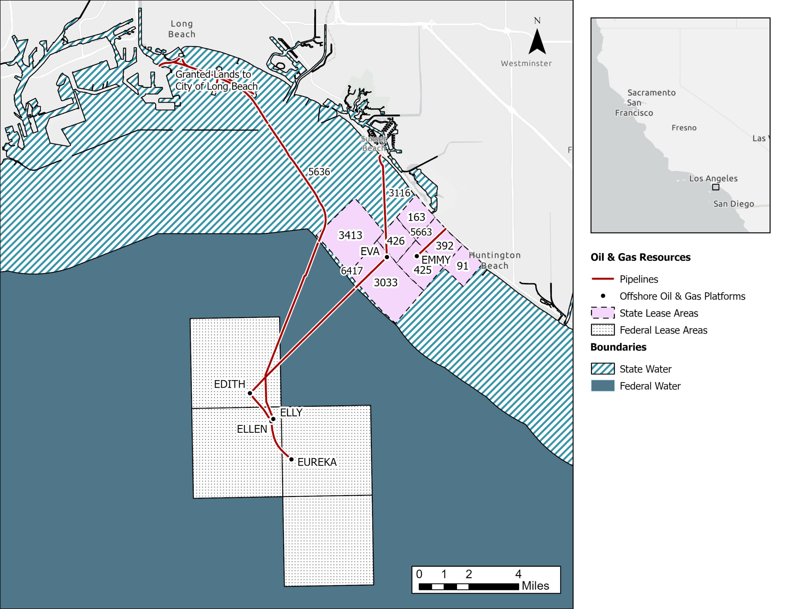
- Which offshore oil and gas pipelines are included in the APTR off of Los Angeles and Orange Counties?
- Are there any pipelines excluded from the APTR?
- What is the Commission’s jurisdiction?
- Are oil and gas production platforms part of the APTR?
- Will potential impacts from oil spills be evaluated?
- What is the timeline?
What is the California State Lands Commission?
The Legislature created the Commission in 1938 as an independent body composed of the Lieutenant Governor, the state Controller, and the Governor’s Director of Finance. While the Commission has some regulatory functions, it is mainly a land and resource management agency. The Commission manages sovereign public trust lands, which are lands that became state property when California became a state and are held by the state in trust for the people. The Commission manages these lands consistent with the Public Trust Doctrine and in the best interest of the state. The Public Trust Doctrine is a common law doctrine that ensures that sovereign lands are used for public uses, such as commerce, navigation, fishing, recreation, and open space. Public access is a key element of the Public Trust Doctrine because these lands belong to the public. The Commission negotiates leases for the use of these lands.
How many pipelines are included in the APTR and where are they located?
Nine offshore oil and gas pipeline leases covering 19 oil and gas pipelines are included in the APTR. The geographic area spans from Santa Barbara County in the north to Orange County in the south.
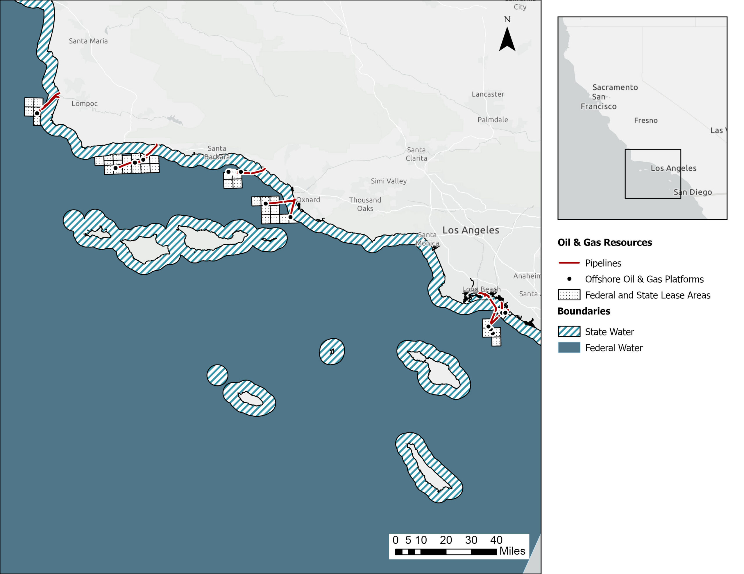
Which offshore oil and gas pipelines are included in the APTR off of Central and Northern Santa Barbara County?
| Lease | Owner/Operator | Servicing Platform | Assets |
|---|---|---|---|
| 6911 | Freeport-McMoRan Oil and Gas/DCOR | Irene | Two oil pipelines; one gas pipeline |
| 4977 | Sable Offshore | Hondo | One gas pipeline |
| 7163 | Sable Offshore | Harmony | One oil pipeline; one produced water outfall |
Which offshore oil and gas pipelines are included in the APTR off of southern Santa Barbara and northern Ventura Counties?
| Lease | Owner/Operator | Servicing Platform | Assets |
|---|---|---|---|
| 4017 | DCOR | Platform A | One oil pipeline; one gas pipeline |
| 5967 | DCOR | Gina and Gilda | Two oil pipelines; two gas pipelines |
Which offshore oil and gas pipelines are included in the APTR off of Los Angeles and Orange Counties?
| Lease | Owner/Operator | Servicing Platform | Assets |
|---|---|---|---|
| 5636 | Beta Offshore | Elly | One oil pipeline |
| 3116 | DCOR | Eva | One oil pipeline; one gas pipeline |
| 6417 | DCOR | Connects Eva to Edith | One oil pipeline |
| 5663 | CRC | Emmy | One oil pipeline; two gas pipelines |
Are there any pipelines excluded from the APTR?
Yes. The original APTR scope included two leases from Platform Hermosa to shore (Santa Barbara County) and one lease from Platform Esther to shore (Orange County). These leases were subsequently removed from the APTR because the pipelines under these leases have been or are in the process of being decommissioned.
What is the Commission’s jurisdiction?
The Commission has jurisdiction over ocean waters extending from the mean high tide line to approximately 3 nautical miles offshore, the beds of bays and estuaries, and navigable lakes and rivers.
Are oil and gas production platforms part of the APTR?
No, oil and gas production platforms are outside the scope of the APTR as mandated by the Commission when it authorized the APTR in December 2023 (Item 59).
Will potential impacts from oil spills be evaluated?
Yes. For each lease that contains an oil pipeline, oil fate and transport modeling is being conducted. The spill model will provide detailed predictions of three-dimensional trajectory, fate, biological effects, and other impacts of spilled oil.
In addition to modeling spills from pipelines, spills from potential pipeline alternatives will also be modeled (two hypothetical Southern California spills from importing oil tankers).
What is the timeline?
Staff anticipates releasing the draft APTR for public comment in Spring 2027.
Public Information Webinar - 2 p.m.
Thursday, August 13 at 2 p.m.
Join Zoom Meeting
Join by Phone: 1.213.338.8477
(International numbers available)
Webinar ID: 857 6845 1406
Passcode: 335337
Public Information Webinar - 6 p.m.
Thursday, August 13 at 6 p.m.
Join Zoom Meeting
Join by Phone: 1.213.338.8477
(International numbers available)
Webinar ID: 870 9456 2933
Passcode: 809683
For questions, contact:
Amy Vierra or Gordon Huang at CSLC.OffshorePipelines@slc.ca.gov
Or by mail:
California State Lands Commission
Attn.: Amy Vierra
100 Howe Avenue, Suite 100 South
Sacramento CA 95825